Friday, July 31, 2015

The Open Sea, an Old Friend


Whale in Fisher Channel
After a short respite at Shearwater and filling the batteries with water, we were off once again departing via Lama Passage then south along Fisher Channel where we had the pleasure of seeing two whales surface and submerge near the shore.  The skies were clear, the winds light, and sea chop moderate, a pleasant day for another five-hour run to our next anchorage.  
Whale submerges in Fisher Channel
Upon reaching Fitz Hugh Sound, we turned west into Hakai Passage which leads out to the open ocean.  This is where we experienced the open sea for the first time back in 2011; we were wide-eyed and amazed by the ocean swell, now something that has become routine.  
Heading between the Planet Islands
From Hakai Passage we turned north through the Planet Island Group then into Edward Channel running between Underhill Island and Stirling Island, an area we had not previously explored.  We wound our way through tiny islands and rocky islets before turning west into Lewall Inlet which cuts through the middle of Stirling Island almost dividing it in half. 
Lewall Inlet, a challenging and narrow hide-away
Lewall Inlet is extremely narrow with rocks and shoals lying just beneath the water’s surface.  We motored slowly until we reached the end where it widens enough for suitable anchorage.  If you don’t want to be found, this is definitely the spot, it’s a hide-and-seek kind of place.  We found our way out the following morning from our little hide-away and motored across Hakai Passage to one of our favorite destinations, Pruth Bay located between Hecate and Calvert Islands.  
Looking out to Sea from Hakai Passage
Pruth Bay is the site of the Hakai Beach Institute, a teaching and research center and conference facility.  Trails which have recently been improved lead across the island to beautiful ocean beaches.  Seeing that there were more than a dozen boats in the harbour, we decided to continue on and make more progress southward while retaining the cherished memories of this pretty location.  
Lovely Pruth Bay
We motored out Kwakshua Channel back to Fitz Hugh Sound and turned south; the weather window was still good to round Cape Caution by day’s end.  As we exited Fitz Hugh Sound the seas began to build with typical 4-5 foot westerly swells, fortunately accompanied with only light winds.  At 2pm we rounded the Egg Island Lighthouse putting us in a southeasterly heading and a more comfortable angle with the swell.  
Dall's Porpoise playing off our Bow
About a half-hour later we made another turn eastward to round the southern half of Cape Caution.  The seas had subsided to two feet and Dall’s Porpoise came to play with Got d’ Fever.  We were now entering Queen Charlotte Strait, the area between the north tip of Vancouver Island and the B.C. mainland coast of the Broughton Island region.  The seas had flattened to one foot chop until we reached Ripple Passage through the small Walker Island Group; the passage lived up to its name with a 2-3 knot current which slowed our progress and required disengaging the auto pilot and hand steering Got d' Fever  through the surf.  Dozens of birds flocked to the stirring waters that boiled fish to the surface for easy prey.  Soon we were through Ripple Passage and arrived at Blunden Harbour, a popular sheltered anchorage for boats waiting for weather to round Cape Caution or to head south across Queen Charlotte Strait.  We found a spot to anchor among the other boats that had already arrived and managed to set the hook despite the early evening brisk winds.  By tomorrow afternoon we would be enjoying a wonderful pig roast at Pierre’s Marina in the Broughton’s.

Wednesday, July 29, 2015

Shearwater, an Oasis


Anchorage at Refuge Cove
At Refuge Cove, we were greeted in the morning by the warmth of the sun and a bright blue sky, a pleasant change from the previous three days of rain.  
Mathieson Channel
We turned south down Mathieson Channel continuing through Perceval Narrows and out to sea where we met gentle five-foot ocean swells, a familiar old friend.  Rounding several small islands and the scenic Surf Lighthouse, we headed eastward along Seaforth Channel to the village of Shearwater.  


Surf Lighthouse at entrance to Seaforth Channel 
We felt as if we had reached civilization once again; it is funny how the smallest of towns and villages can seem like civilization after spending time in remote anchorages and inlets.  It didn’t surprise us that the marina at Shearwater was completely filled with boats along with several boats anchored in the harbour.  
Shearwater on Denny Island
Shearwater on Denny Island is a major crossroads for points north and south, a little oasis in the region.  We set the hook in the harbour and took the dinghy ashore for a pleasant dinner, soaking up the sun on the deck of the restaurant, ah!  
Enjoying the Sun at Fishermen's Bar & Grill, Shearwater
Fishermen’s Bar & Grill has surprisingly good food and nice service provided by seasonal help who come from various parts of Canada.  Since our last visit, we noted a new coffee shop and a new gift shop said to have opened just a month ago.  The latest addition to Shearwater is a large model of a Stranraer Aircraft.  Stranraers were assigned to Shearwater during WWII to conduct patrols after the Japanese attack on Pearl Harbor.  
Model of the Stranraer Aircraft
The day following the attack Nos. 949 and 936, the only “Stranies” assigned to the station at that time, commenced patrols after a report of a Japanese submarine being sighted north of Vancouver Island.  In 1944 most of the Stranraers were withdrawn from service and replaced with the Consolidated Canso or Catalina Flying Boats.  
Stranraer Model at Shearwater
These flying boats were used for anti-submarine warfare, patrol bombing, convoy escorts, search & rescue, and cargo transport.  The old Stranraer No. 949 was sold in 1949 to the Queen Charlotte Airlines and later served with the Pacific Western Airlines until 1957 when it crashed in a lake near Quesnel, B.C.  
The old Aircraft Hanger, Shearwater
The old aircraft hanger still stands at Shearwater and is currently used as a work shop and for storage.  The McNaughton group of islands south of Shearwater located off the shores of Hunter Island were given aircraft names by the Navy pilots of the 1940’s, these names were used to report their positions, names which still remain today.

Tuesday, July 28, 2015

Landon’s Ark


Before continuing south we spent two days in Prince Rupert taking care of chores including changing the engine oil, grocery shopping, laundry, and topping off with fuel.  While at the docks we met a couple from Westbay, Rhode Island.  They had shipped their boat to Victoria B.C. from back East and were looking forward to cruising Southeast Alaska.  Coincidently their boat is a DeFever which they named “Got the Fever.”  We exchanged contact information and they departed heading north but I had this nagging feeling that they would soon be back.  Sure enough, they arrived back at the Prince Rupert docks a few hours later; one of their Ford Lehman engines stopped running which they said had happened once or twice before but they were able to restart it again.  Since we have John Deere engines the only suggestion we had was that it might be a defective solenoid or servo with a valve that’s intermittently closing off fuel flow.  We also mentioned that they could have parts flown from Fisheries Marine Supply in Seattle to Ketchikan, Alaska if needed.  
Cruise Ship emerging from the Fog Bank
We assume they were able to start the engine again since they headed out across “Dixon Entrance” for Ketchikan, a town that has more resources available for engine repairs and supplies.  The following morning we made our way southward through banks of fog and heavy rain down a series of channels starting with Inverness Passage, then Telegraph Passage, and then the 45-mile long Grenville Channel which is the waterway equivalent of the I-5 corridor – the main route of the “Inside Passage” to and from Southeast Alaska.  Emerging from the fog bank in Grenville Channel was a large cruise ship; of course we saw him coming on our Radar and AIS so we moved off to the side, giving him plenty of room.  It’s always a little unnerving knowing something that big is headed towards you. 


We finally made our way to the end of Grenville Channel terminating at Wright Sound and anchored for the night in “Coghlan Anchorage” located near the Native boardwalk village of Hartley Bay.  Unfortunately it was quite windy through the night with gusts between 23-35 knots.  The anchor was set well in the mud but it was a rather sleepless night.  Leonard slept on the bunk in the pilothouse and I slept on the settee (couch) in the salon so we could hear the anchor alarm if it were to go off; this arrangement also eliminated having to listen to the waves slap against the bow of the boat which can be heard from our stateroom. 
We managed to get a few hours of sleep and were ready to leave the next morning by 6:20am.  We had another series of channels to follow starting eastward through McKay Reach, then southeast along Fraser Reach, south along Graham Reach, southeast through Hiekish Narrows, and finally south down Finlayson Channel.  
Big Boat, Bigger Falls
The rain did not letup and continued its deluge throughout the day – like Noah’s Ark in the great flood, only Noah didn’t have windshield wipers like the Ark of Landon. 
The waterfalls were gushing down the mountainsides and thundering into the canals, an awesome sight.  From Finlayson Channel we turned east through Jackson Pass and anchored at 5pm in Rescue Bay located at the east end of the Pass.  The rain continued but the anchorage was calm and sheltered us from the wind.

Friday, July 24, 2015

The Tsimshian’s of B.C.


Waters were glassy, calm for the entire trip back down Portland Canal.  After reaching the open sea we turned south through Chatham Sound where we encountered 20-25 knot winds with lumpy 4-5 foot chop.  We sought protection behind Finlayson Island along Tsimpsean Peninsula for part of the way along Chatham Sound.  
Venn Passage through Metlakatla Bay, B.C.
By 6:30pm we entered the protected waters of Duncan Bay, then Metlakatla Bay which serves as a short cut to Prince Rupert, known as Venn Passage.  Metlakatla Bay is the site of the small Tsimshian village of Metlakatla B.C. which should not to be confused with Metlakatla, Alaska (see previous blog post, dated 7/19).  Metlakatla is among the smallest of seven Tsimshian communities in British Columbia.  Metlakatla B.C. is where Father William Duncan established a utopian Christian community made up of Tsimshian Native Tribes, including 350 members from Lax Kwalaams (Port Simpson) located a few miles to the north where he first started his missionary work in 1857.  Today, Lax Kwalaams is the largest of the seven Tsimshian communities in British Columbia.  
Metlakatla, British Columbia
When Father Duncan omitted the Sacrament of Communion in his teachings and practice, he was expelled in 1881 from the Church of England’s “Church Missionary Society;” as a result, he created his own non-denominational “Independent Native Church.”  Shortly after Father Duncan moved his group to Metlakatla B.C., 500 people died of smallpox at Port/Fort Simpson, which he took as a sign from God.  By 1879, his community had grown to 1,100 people.  Then in 1887 with 800 plus Tsimshian’s, he departed on an epic canoe journey to found the new community of Metlakatla, Alaska.  The 100 or so remaining residents of “Old Metlakatla” were left in the hands of Anglican bishop William Ridley, Duncan’s nemesis.  Today, Metlakatla B.C. is still predominately Anglican and is quite dependent on nearby Prince Rupert for resources.  A small ferry runs between Metlakatla and Prince Rupert on a regular schedule.  
Prince Rupert seen from Tsimpsean Peninsula
After transiting Venn Passage, we rounded Tsimpsean Peninsula and anchored in Pillsbury Cove for the night, the lights of Prince Rupert could be seen across the Harbour three miles away.  Outside the village of Metlakatla, scenic Metlakatla Wilderness Trail winds through the forest and along the shores of Tsimpsean Peninsula.  The wilderness trail includes boardwalks and a suspension bridge but is unfortunately closed until further notice due to damage from severe weather conditions – perhaps from the gale-force winds we had this season in late April.

Thursday, July 23, 2015

Hyder AK


Biking across the border into Hyder, Alaska
 
1896 Storehouse at Hyder
It was pouring buckets today but that didn’t stop us from visiting Hyder, Alaska located just two miles from Stewart, B.C.  We donned our rain jackets, pants, and boots and peddled our bikes across the border to the intriguing little town of Hyder.  The rain, mist, and puddles added full measure to the banner overhead – “Welcome to Hyder, Alaska.”  Just inside the border we noticed a small stone structure and stopped to investigate.  It turned out to be a “storehouse” built in 1896 by Captain Gaillard of the U.S. Army Corps of Engineers.  He was ordered to investigate Portland Canal and build four storehouses along the west bank – Storehouse no. 1 and 2 on Pearse Island; Storehouse no. 3 in Halibut Bay (ruins remain); and Storehouse no. 4 at Hyder, still seen today.  Storehouses 1 and 2 are now on Canadian soil as a result of the 1903 Boundary Tribunal decision when the Alaska-Canada border was re-established north of Pearce and Wales Islands.  The storehouse in Hyder is listed on the National Register of Historic Places and is maintained by the Bureau of Land Management.  
A shop for the tourists, Hyder
Hyder was settled by many of the same miners and prospectors that came through Stewart. 
Archival Photo, Hyder
The early pioneers called the Hyder/Stewart settlement Portland City, but when locals made application in 1914 for a postal permit, it was denied on the basis that too many U.S. communities were named “Portland.”  The new name of Hyder was chosen in honor of Frederick Hyder, a respected Canadian mining engineer.  The town’s boom years ended in 1928 when the mines entered a long decline; around the same time a fire swept through the town’s business district. 
The old Trading Post, Hyder
Today Hyder has a population of 94 people who are proud of their mining roots and call their little town in the outback the “Friendliest Ghost Town in Alaska.”  Hyder has several old historic buildings still intact, plus two old-fashioned general stores, and two Gold Rush-era saloons which help to preserve the town’s unique character.  It is interesting to note that Hyder is the only town in Alaska that has no city police, everyone helps keep a watch on the affairs of the community. 
A house or shop from Yester-Year
Hyder is also the only town in Alaska that uses British Columbia’s 250 area code instead of Alaska’s 907 code because Hyder obtains all its electricity and telephone service from the Canadian side of the border.  Our fold-up bicycles came in handy once again for a four-mile trip north of Hyder where a U.S. Forest Service viewing platform is positioned along Salmon Creek.  Visitors can watch salmon spawn from July to September and some visitors are lucky enough to see bear snatching their share of fish from the stream.  
Boardwalk Viewing Platform along Salmon Creek
The salmon run provides an extensive food supply for bears, wolves, eagles, and other birds and animals.  We saw plenty of fish but the bears must have stayed home for an afternoon nap out of the rain.  We watched the fish wiggle through the stream, digging out sand and gravel to lay their eggs.  After spawning, the adult salmon will die, returning their nutrients to the creek ecosystem and a new generation will continue the cycle.  Most Chum salmon spawn in small streams and intertidal zones where they build nests, called a “redd” which are simply depressions in the gravel.  
Spawning Salmon
The female lay eggs in the “redd” and the male sprays milt on the eggs, after which the female covers the eggs with gravel.  After emerging from the gravel as tiny fry, chum and pink salmon quickly migrate to the ocean, while Coho salmon spend up to two years as juveniles in the stream before migrating out to sea.  The rain continued to pour down and never let up; we endured the four-mile bike ride back to Hyder and pulled up to the check point with passports in-hand.  We must have been a strange sight waiting on our bicycles to cross the border into Canada.  Another two miles and we were back at the boat ready to dry off and warm up with a hot cup of tea.

Wednesday, July 22, 2015

Stewart B.C.

Tide Flats in front of Stewart, B.C.

We enjoyed our visit to Stewart which proved to be a fun town with an interesting past.  Settlement and mineral prospecting took place at the head of Portland Canal with the arrival of 68 prospectors in 1898 followed by the Stewart brothers, Robert and John, who arrived in 1902 and laid out a town site forming the Stewart Land Company.  

Stewart B.C.
Stewart and Hyder (then known as Portland City) were at that time joined by a two-mile long “road” on pilings across the tide flats.  These pilings are still visible today running through the estuary in both Stewart and Hyder. 

Stewart B.C.
Gold and silver mining had caused a rapid growth bringing 10,000 people to the area but the population declined during the war years.  In 1916, gold and silver were again discovered near Stewart which became the famous Silback Premier Gold Mine, one of British Columbia’s richest gold-silver mines which supported Stewart and Hyder until the 1950’s.  
Church in Stewart, a beautiful backdrop
Later the Granduc Copper Mine was the main employer until 1984.  Today Stewart has a population of 500 people with all the necessary amenities, but the early days of mining have left a legacy of artifacts and historic buildings in both Stewart and Hyder.  We didn't want to miss the sights having made the long venture up Portland Canal so we got out our bicycles and rode into town.  As we biked from the marina towards Stewart, we discovered a boardwalk that leads over a portion of the tide flats, a nice shortcut into town for hikers and bicyclists!  
Glacier-like Snow Field above Stewart
The boardwalk is also a great place for bird watching and provides excellent views of the mountains and snow fields seen high above town.  
Boardwalk over Tide Flats, Stewart
We found several interesting buildings from the old mining days including the large abandoned 
Abandoned 1908 Empress Hotel
Empress Hotel built in 1908, which also served as a base for the Canadian Northeastern Railway.  The refurbished Stewart Fire Hall, constructed in 1910, now serves as a museum.  
Old Fire Hall & Museum
1898 Log Cabin on Museum grounds at Stewart
On the museum grounds is an original 1898 log cabin that once belonged to DJ Rainey, one of the first settlers and prospectors to the area.  
Boardwalk leading out of Town
Of course we had to stop by the bakery in town and enjoy an early dinner at the cute Dash Bistro which has some very tasty dishes.
Enjoying the Ride

Tuesday, July 21, 2015

Portland Canal


We departed Metlakatla on July 20th in the afternoon, facing southerly winds of 10 knots with 3-5 feet seas and made our way between the fishing boats and nets typically seen during the month of July.  We soon turned eastward rounding the south end of Annette Island to anchor for the night in Ryus Bay on the north end of Duke Island.  The following morning we headed across “Dixon Entrance,” the large open body of water that separates U.S. Alaska from B.C. Canada, managing the 5-6 foot ocean swells as we rounded Cape Fox and entered Nakat Bay in Alaskan waters.  Boaters must clear customs before anchoring or making landfall and Prince Rupert is the designated port-of-call when entering Canada from the north by boat.  But what if you want to see the towns of Hyder and Stewart located north of Dixon Entrance up the 100-mile long Portland Canal – Hyder Alaska and Stewart B.C. are separated by only two miles within bicycle distance of each other.  It’s certainly not practical for boaters to journey 65 miles south to Prince Rupert and then back north to Dixon Entrance in order to make the 100 mile journey up Portland Canal to visit Stewart on the Canadian side of the Canal.  According to the marine guidebooks, boaters may be able to clear customs by phone for this remote side trip into Stewart.  After calling the customs officer at Prince Rupert, I was directed to call “Canpass” located on the East Coast to obtain a customs clearance number.  The East Coast office had no idea where Stewart was located not to mention the challenge of reaching this port by boat.  
Passing a Fishing Boat in narrow Tongass Passage 
To make a long story short, the customs officer in Prince Rupert told me to call Canpass again and that if they needed additional information they could call him directly, this is exactly what transpired and we finally received a customs clearance number.  Since Hyder/Stewart has no cell phone reception, clearance into Stewart had to be done ahead of time.  Ok, back to Nakat Bay, from here we entered Tongass Passage to reach Pearse Canal which becomes Portland Canal; the international boundary more or less follows through the center of this waterway.  


Fishing Boat Bringing in Net, Tongass Passage
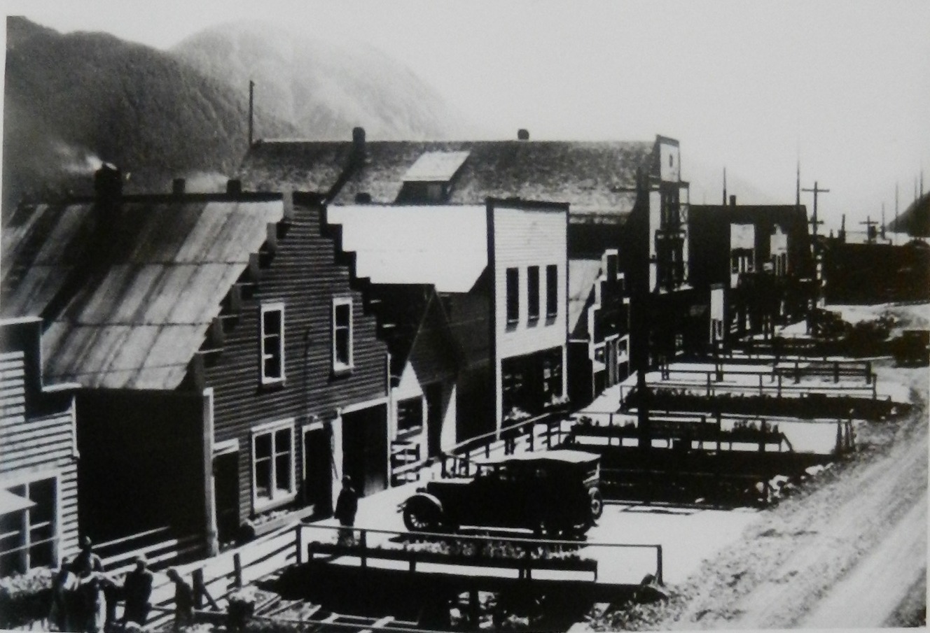
Although Stewart/Hyder is accessible by car through B.C. it is a challenging destination to reach by boat.  Portland Canal is subject to strong winds that blow up and down the waterway with considerable force and the limited anchorages are somewhat marginal.  The weather forecast predicted strong westerly winds so we planned to anchor in Halibut Bay, reported to be one of the better anchorages along Portland Canal.  We arrived at Halibut Bay around 5pm and the wind was howling at 20 knots blowing right into the bay; apparently westerly winds become southerly in Portland Canal, sweeping through the mountain valleys and up the Canal.  We made several attempts to set the anchor but couldn’t get a solid bite.  The spot in the bay with the least amount of wind had a rocky bottom so the anchor pulled loose and skipped along the sea floor.  
Whiskey Bay Anchorage
So w
e went to Plan B and motored for two hours back south to Whiskey Bay at the north end of Pearse Island in the middle of Portland Canal with better protection from southerly winds.  If Plan B proved fruitless, we would go to Plan C – motor slowly overnight north to Stewart arriving the following morning at daylight.  Indeed, Whiskey Bay proved to be a better shelter for southerly winds and we found the waters to be much calmer.  We set the hook around 9pm and went to bed having had dinner while underway.  
Portland Canal
Calmer seas greeted us the following day with sun peaking through the clouds illuminating the mountains rising steeply above the Canal.  This fjord-like canal is a display of mountain peaks rising to over 7,000 feet with snow fields and glaciers.  
Beautiful Turquoise Water
The beautiful turquoise water is colored by the glacier runoff but turns a milky white at Hyder/Stewart from the Salmon River and Bear River outflows.  The head of Portland Canal was called “skam-a-kounst” by the Native Nisga’a tribe, meaning “safe place,” presumed to be in reference as a retreat from the neighboring coastal Haidas.  
One of Many Falls along Portland Canal
As we neared Hyder/Stewart, the winds began to pick up again as we made our way into port.  
Portland Canal
We could see that the public docks were filled with mostly sport fishing boats with limited space for larger boats. 
Fortunately we found ample side-tie along a float located next to a shed; pointing Got d’ Fever into 20 knot winds, we maneuvered her into position despite strong current from the opposite direction, and quickly secured her to the float.  We noted that the float was attached to the main docks with a very rusty chain held in place with some rusty old nails driven into the logs, not the most reassuring of circumstances. 
Leonard commented that this was the first time he had to set an "anchor watch" while tied to a dock - we
 wouldn’t want to drift away with a float still attached to the boat!